Damage Assessment Sioux, Grant, LaMoure, and Logan Counties-Updated July 15
Sioux County
IN SIOUX COUNTY SIGNIFICANT HAIL DAMAGE WAS REPORTED IN THE AREAFROM SOLEN TO CANNONBALL...TO THE PRAIRIE KNIGHTS RESORT. ABOUT ONE
HUNDRED BUILDINGS WERE DAMAGED. SOME HOMES HAD HAILSTONES CRASH
COMPLETELY THROUGH THE ROOF WITH WINDOWS BROKEN ON THE WEST SIDE. A
SIGNIFICANT NUMBER OF VEHICLES WERE DAMAGED...INCLUDING FRONT AND
REAR WINDOWS COMPLETELY SMASHED OUT. SIGNIFICANT CROP DAMAGE WAS
ALSO REPORTED.
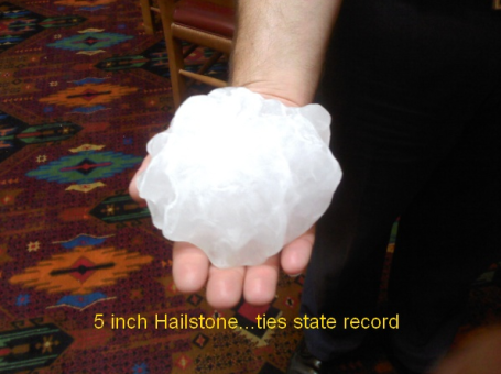
MOST HAIL WAS GOLFBALL TO SOFTBALL SIZE, THE LARGEST STONES FELL
AT THE PRAIRIE KNIGHTS RESORT AND SOME WERE 5 INCHES IN DIAMETER.
THIS TIES A NORTH DAKOTA STATE RECORD SET ON AUGUST 3, 1969 IN
MERCER COUNTY. THESE HAILSTONES CRASHED COMPLETELY THROUGH THE FRONT
WINDSHIELD OF VEHICLES INJURING 2 PEOPLE. ONE OF THE INJURED WAS
TRANSPORTED TO A LOCAL HOSPITAL. THERE WERE ALSO LARGE HAIL DIVOTS
IN THE GROUND.
Picture from Prarie Knights:

5 Inch hailstone:

NATIONAL WEATHER SERVICE ASSESSMENT TEAMS SPOKE WITH MANY TRIBAL
OFFICIALS INCLUDING VICE CHAIRMAN MIKE FAITH AND EMERGENCY MANAGER
JOHNELLE LEINGANG. WE ALSO SPOKE WITH OTHER FEDERAL GOVERNMENT
AGENCY OFFICIALS...PRAIRIE KNIGHTS RESORT MANAGEMENT AND LOCAL
RESIDENTS.
Grant County
THE NATIONAL WEATHER SERVICE DAMAGE ASSESSMENT TEAM DETERMINEDTHAT...IN GRANT COUNTY...VERY SIGNIFICANT HAIL DAMAGE...AND SOME
WIND DAMAGE...EXTENDS ACROSS THE ENTIRE WIDTH OF THE COUNTY ALONG
AND SOUTH OF HIGHWAY 21. THIS IS FROM NEW LEIPZIG...THROUGH
ELGIN...HEIL...LEITH...RALEIGH...AND SAINT GERTRUDE...TO JUST
NORTH OF SHIELDS. THERE IS A ROUGHLY 3 MILE WIDE SWATH OF CROP
DAMAGE ALONG THIS PATH.
Photo from Heil area:

NO TORNADO DAMAGE WAS OBSERVED...HOWEVER...FIRE OFFICIALS WHO WERE
OUT SPOTTING DID SEE A FUNNEL CLOUD JUST SOUTH OF ELGIN. IT DID
NOT TOUCH THE GROUND AND QUICKLY RETREATED BACK INTO THE STORM.
THE FUNNEL WAS MADE VISIBLE BY LIGHTNING.
MOST HAIL STONES ACROSS THE COUNTY WERE GOLF BALL TO TENNIS BALL
SIZE...1 3/4 TO 2 1/2 INCHES DIAMETER. THE LARGEST STONES FELL 3
MILES SOUTH OF ELGIN AND WERE ABOUT 4 1/2 INCHES DIAMETER. THIS
WAS ALSO THE LOCATION OF HIGHEST WIND GUSTS...ESTIMATED AT 70 MPH
BASED ON ROOF DAMAGE TO OUTBUILDINGS ON A RANCH. EYE WITNESSES
DESCRIBED VERY HIGH WIND TO START...FOLLOWED BY THE HAIL. HORSES
HAD WELTS ALL OVER THEM AND ONE HAD PHYSICAL DAMAGE TO ITS SNOUT.
THREE WAVES OF STORMS CROSSED THE COUNTY. SPECIFICALLY AT HEIL THE
FIRST ONE WAS THE WORST...THE SECOND HAD SLIGHTLY SMALLER
HAIL...AND THE THIRD THE SMALLEST...ABOUT QUARTER SIZE. MANY
PEOPLE DESCRIBED A SIMILAR SCENARIO AS THE STORMS PASSED THROUGH
THEIR AREA.
LIGHTNING STRIKE FIRE...ON THE WEST SIDE OF ELGIN...LIGHTNING FROM
THE THIRD STORM THAT PASSED STRUCK THE CHIMNEY OF A HOUSE...
FOLLOWED THE CHIMNEY TO THE BASEMENT AND STARTED A FIRE IN THE
BASEMENT AND ON ALL THREE LEVELS OF THE HOME IN THE ELECTRICAL
WIRING. FIRE OFFICIALS SAID THAT WHEN THEY ARRIVED ON THE SCENE
THE METAL ANTENNA ON THE CHIMNEY WAS GLOWING BRIGHT ORANGE. THE
HOME OWNER STATED THAT THEIR INSURANCE AGENT DETERMINED THE HOME
WAS A TOTAL LOSS. A FAMILY OF 5 OCCUPIED THE HOME...ALL GOT OUT
SAFELY.
THE NATIONAL WEATHER SERVICE ASSESSMENT TEAM SPOKE WITH EMERGENCY
MANAGER JOANN OZBUN...ELGIN CITY POLICE CHIEF AND FIRE OFFICIALS
...AND MANY AFFECTED COUNTY RESIDENTS. THANK YOU FOR TAKING THE
TIME TO HELP US BETTER UNDERSTAND THE WEATHER EVENTS THAT OCCURRED
ACROSS YOUR COUNTY.
LaMoure County
A STORM SURVEY WAS CONDUCTED IN LAMOURE COUNTY DURING THE AFTERNOONOF WEDNESDAY JULY 14. SIGNIFICANT WIND DAMAGE WAS OBSERVED AROUND
THE GRAND RAPIDS AND LAMOURE AREAS FROM SEVERE STORMS WHICH IMPACTED
LAMOURE COUNTY DURING THE EARLY MORNING HOURS OF JULY 14TH.
EXTENSIVE WIND DAMAGE TO CORN FIELDS WAS OBSERVED FROM AROUND COUNTY
HIGHWAY 35...SOUTH AND EAST THROUGH GRAND RAPIDS AND TOWARDS THE
CITY OF LAMOURE. CORN STALKS WERE BENT OVER FROM NORTHWEST TO
SOUTHEAST WITH NO DEFINED PATH OBSERVED WHICH IS INDICATIVE OF
STRAIGHT LINE WINDS. THE MOST SEVERE WIND DAMAGE WAS AROUND THE
GRAND RAPIDS AREA WHERE SIGNIFICANT TREE DAMAGE OCCURRED INCLUDING
NUMEROUS MATURE HARDWOOD TREES UPROOTED OR SNAPPED IN HALF. DAMAGE
IN GRAND RAPIDS ALSO CONSISTED OF ROOF DAMAGE TO POLE BARNS AND
SEVERAL GRAIN BINS DESTROYED. IN THE CITY OF LAMOURE...WIDESPREAD
TREE DAMAGE WAS ALSO OBSERVED. MOST DAMAGE CONSISTED OF TREE
BRANCHES BLOWN OFF OF TREES...HOWEVER NUMEROUS TREES HERE WERE ALSO
UPROOTED OR SNAPPED. IN ADDITION...A POLE BARN WEST OF LAMOURE
SUSTAINED HEAVY ROOF DAMAGE AND LARGE DOORS BLOWN INTO THE BUILDING.
ACROSS THE ENTIRE SURVEY AREA...LARGE 1300 POUND HAY BALES WERE
BLOWN ACROSS FIELDS...SOME BLOWN 300-500 YARDS. IRRIGATION EQUIPMENT
BETWEEN GRAND RAPIDS AND LAMOURE WAS ALSO KNOCKED OVER/TURNED ON ITS
SIDE.
THE DAMAGE OBSERVED ACROSS THE ASSESSED AREA WAS BROAD WITH NO
DEFINED DAMAGE PATHS...AND ALL TREE AND STRUCTURAL DEBRIS WAS BLOWN
FROM NORTHWEST TO SOUTHEAST. THE CONCLUSION OF THE STORM SURVEY WAS
THAT VERY STRONG STRAIGHT LINE THUNDERSTORM WINDS WERE RESPONSIBLE
FOR THE DAMAGE. THE SEVERITY OF THE WORST DAMAGE OBSERVED INDICATES
STRAIGHT LINE WINDS UP TO 105 MPH.
THE NATIONAL WEATHER SERVICE ASSESSMENT TEAM INCLUDED LAMOURE COUNTY
EMERGENCY MANAGER SHERI GARTNER...WHOSE HELP WAS CRITICAL WITH THE
STORM SURVEY. MANY AFFECTED COUNTY RESIDENTS WERE ALSO GRACIOUS IN
SHARING INFORMATION. THANK YOU FOR TAKING THE TIME TO HELP US BETTER
UNDERSTAND THE WEATHER EVENTS THAT OCCURRED ACROSS YOUR COUNTY.
Pictures from LaMoure County:


Logan County
A STORM SURVEY WAS CONDUCTED IN FAR NORTHEASTERN LOGAN COUNTY DURINGTHE AFTERNOON OF WEDNESDAY JULY 14. WIND DAMAGE WAS OBSERVED AROUND
THE GACKLE AREA FROM SEVERE STORMS WHICH IMPACTED LOGAN COUNTY
DURING THE EARLY MORNING HOURS OF JULY 14TH. NUMEROUS TREE BRANCHES
WERE BLOWN OFF OF TREES...INCLUDING ONE TREE WHICH WAS SNAPPED IN
HALF WITHIN THE CEMETERY ON THE WEST SIDE OF TOWN. OTHER OBSERVED
DAMAGE CONSISTED OF A FLAG POLE BENT OVER AND A TELEVISION ANTENNA
BLOWN OFF OF A ROOF.
THE CONCLUSION OF THE STORM SURVEY WAS THAT STRONG STRAIGHT LINE
THUNDERSTORM WINDS WERE RESPONSIBLE FOR THE DAMAGE...ESTIMATED
BETWEEN 60 AND 75 MPH.
FURTHERMORE...LOW LYING AREAS OF COUNTY ROAD 67/63RD AVENUE
SOUTHEAST NEAR SMALL LAKES AND STREAMS BETWEEN GACKLE AND INTERSTATE
94 SHOWED SIGNS OF RECENT FLASH FLOODING. WATER WAS FLOWING FREELY
OVER ONE AREA...WITH SEVERE EROSION OVER SEVERAL OTHER LOW LYING
AREAS OF THE ROAD.
THE NATIONAL WEATHER SERVICE ASSESSMENT TEAM WAS DIRECTED TO
NORTHEAST LOGAN COUNTY AFTER EARLIER COMMUNICATION WITH THE LOGAN
COUNTY EMERGENCY MANAGER CYNTHIA DOLL. THANK YOU FOR TAKING
THE TIME TO HELP US BETTER UNDERSTAND THE WEATHER EVENTS THAT
OCCURRED ACROSS YOUR COUNTY.
Picture from Logan County (Gackle):


JP Martin/B. Selzler/K. Simosko/N. Heinert
*****************************************************************************
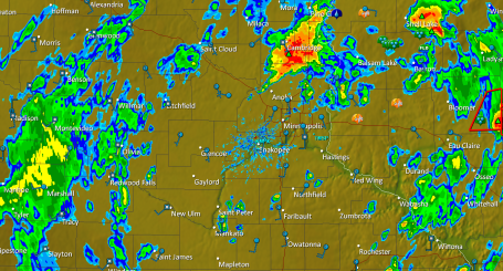
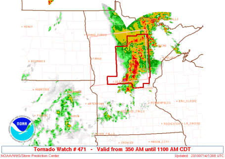
Significant Tornado Risk Later Today


Weather Headlines
* Today: significant risk of widespread severe storms by late afternoon/evening (moderate risk of severe weather from SPC directly over central/southern MN).
* Large hail, violent straight-line winds, even a few isolated tornadoes expected (best chance around the dinner hour). Potential for 3-6 tornadoes, even 1 or two larger, long-lasting EF2+ strength tornadoes possible.
* Today: 7th day this summer season above 90 F.
* NAM/WRF model printing out nearly 2" of rain by breakfast Sunday morning - potential for minor flooding problems tonight.
* Tomorrow: "breath of fresh air" as winds turn around to the northwest with a BIG drop in humidity and a mix of clouds and sun - dry Sunday expected across most of Minnesota.
Paul's Star Tribune Outlook for the Twin Cities and all of Minnesota
Today: Sunny, sticky and hot. A high threat of strong/severe storms by late afternoon and evening, a few will be severe, with large hail, damaging winds, even an isolated tornado. Stay alert after 3 pm. Winds: S 10-15. Dew point: 65-70. High: 92
Saturday night: Severe storms possible evening hours. Heavy T-storms overnight, minor flash flooding can't be ruled out. Low: 69
Sunday: MUCH better! A damp start giving way to plenty of sun, breezy and noticeably less humid. Winds: NW 10-20. High: 84
Monday: More clouds than sun, isolated PM shower or T-shower possible - cooler. High: 77
Tuesday: Warmer with a few scattered T-storms. High: 83
Wednesday: Partly sunny, sticky. High: 89
Thursday: Heating up, lot's of sun, hazy and humid. High: 92
Friday: Lot's of sun, feels like summer. High: 91
 Fine Friday. The sun was out statewide yesterday, highs ranging from 77 at International falls to 90 in the Twin Cities and Redwood Falls to 91 in St. Cloud. A few severe storms bubbled up south of Owatonna by late afternoon, turning tornadic as they swept across Iowa Friday evening.
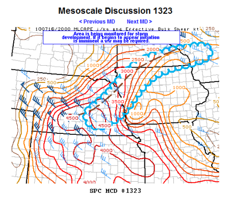
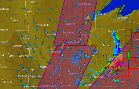
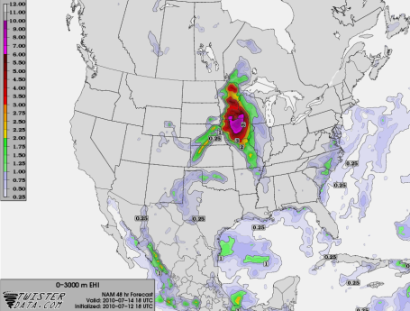
 Tornado Bulls-Eye. This graphic shows predicted "helicity" around lunchttime today, a 350-450 value directly above St. Cloud and Brainerd, meaning powerful spin in the lowest few thousand feet of the atmosphere, rotation which can (in theory) be focused around a violent thunderstorm updraft, resulting in isolated tornadoes. Meteorologists start to get nervous when helicity values reach 200-300. A value over 400 (combined with other factors) is a red flag that today's storms probably won't be "garden variety."
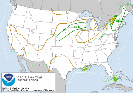
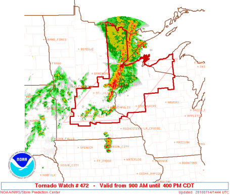
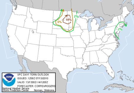
 Ripe. There are 3 "flavors" of SPC severe storm risk: slight, moderate and high. A "high" risk may come around 2-3 times an entire season. Moderate is serious enough, implying a high confidence from severe storm specialists working for SPC/NOAA in Norman, Oklahoma that storms will not only become severe, but conditions exist for severe storms to produce especially violent winds, including tornadoes. The 45% hash mark means a 45% probability of severe weather (58 mph+ winds and/or 1"+ diameter hail) within 25 miles of any town within that region. Translation: batten down the hatches. See the very latest update from SPC here.
Hop up on the severe-storm-treadmill. C'mon, it'll be fun! We can explore the wonders of our favorite basements, listen to lightning-induced static on the AM Radio, or maybe tune in the funky, robotic voice warbling out of the nearest NOAA Weather Radio, enjoy a siren serenade together. The PERFECT set-up would be a big-screen HD, web-enabled TV under the stairs, maybe slip in a Blu ray disk of "Twister" while we sit....and wait...and wonder...and worry...and fidget, hoping this won't be that one-in-a-million fluke where there's a 30 second rumble and roar, and precious little left when we wander back up the stairs?
Will today be the day we win (lose?) Minnesota's Tornado Lotto?
Odds are (99.99%) your home will still be there tomorrow, safe and sound. Intact. The odds of you (or any of us for that matter) encountering a tornado are slim to nil, but not zero. SPC has raised the severe threat to "moderate" over central and southern MN. Once again we're faced with a witch's brew of ingredients: low-level moisture (dew points may hit 70 by evening), strong instability (unusually cold aloft) and powerful wind shear - what meteorologists call "helicity" (which sounds like a great name for a cat, come to think of it). I fear I may have gotten too much sun yesterday. Helicity is a measure of spin, or "shear", winds changing direction and speed as you rise up through the atmosphere. The stronger (and more varied) the winds in the lowest few thousand feet of the atmosphere, the greater the potential for a severe storm to focus all that spin and conjure up a tornadic circulation that reaches the ground, on the boundary between a violent updraft - air shooting straight up at 100+ mph, and a rain/hail-cooled downdraft.
Plan on a rash of watches/warnings later today - I have a strong hunch that SPC will issue a tornado watch for the mid afternoon through evening hours. Storms may fire up near Alexandria or Wadena, then race to the east/southeast at 30 mph. Personally, I'd go about my normal activities today (try to front-load your outdoor stuff into the morning and midday hours) but keep an eye on the sky after lunch, have multiple safety nets (ie stay tuned to radio, TV, check warnings on your smart phone). Don't just rely on the sirens, whatever you do - bad idea. If you're heading out later in the day calmly ask yourself "where would you go if a warning was issued right now - here?" Scope out the venue - can you get below ground, below grade? Are you exposed to outer walls, windows or glass nearby? Can you find a small, windowless room (with nothing flying off the shelves?) Maybe it's just because I'm a weather geek, but on the big tornado days I'm always more aware of my surroundings, and where I could dash if the REAL DEAL unfolded overhead. The day you say, "oh, they're full of horse-hooey, they blab about tornadoes, we NEVER see tornadoes here..." THAT will be the day Mother Nature may wipe the smile off your face. People in Wadena didn't think they'd actually see an EF-4 tornado back on June 17. Folks living near Northfield probably didn't expect an actual tornado to skip across lawns and fields in town last Wednesday. Tornadoes always happen "somewhere else", right?
I'm pretty sure Minnesota will experience a handful of tornadoes later today, maybe as many as 3-6 separate circulations. Based on the dynamics and meteorological set-up there probably will be damage - hopefully no injuries, but every set-up like this I hold my breath, praying that any tornadoes strike fields, not towns - hold my breath that weather-wise Minnesotans will plug into local media and take any warnings seriously - not blow them off. BTW, a friend pointed out the obvious: we shouldn't be too shocked about the recent rash of severe storms, coming after a strong El Nino earlier this year. As it turns out, El Nino events are often followed by unusually busy severe storm seasons in Minnesota. This is vaguely reminiscent of 1998, another big El Nino year, in fact that was the Mother of All El Nino's, the strongest ever recorded.
The sun should be out during the morning, midday and early afternoon hours, and the good news: winds won't be as strong on your favorite lake, blowing from the south at 5-15 mph. You will feel the humidity rising, no question about that, and if the sun is out for at least 3-5 hours (likely) we should see low 90s by 3 pm or so. That's when the storms may begin to fire off, mid or late afternoon, reaching peak intensity around the dinner hour, possibly mutating into an MCS, a mesoscale convective system, during the evening/overnight hours. The WRF/NAM prints out roughly 2" of rain for the metro area Saturday night, which (if it verifies) would imply flash flooding in some communities. With a dew point near 70 the atmosphere will be supercharged, energized, plenty of fuel for severe thunderstorms by late afternoon, and potentially torrential rains later in the evening.
Sunday will be a HUGE improvement as winds whip around to the northwest, pushing heavy storms (and stifling humidity) into toward Chicago - leaving us with plenty of sun and nearly HALF as much water in the air by Sunday evening. Count on blue sky much of the day (after a soggy start) with highs in the low to mid 80s, and a stiff wind blowing from the northwest at 10-20 mph. Sunday will restore your faith in a Minnesota July: sun, without the scattered tornadoes thrown in.
An isolated T-storm may pop late Monday, again Tuesday, but the rest of the week looks dry and increasingly hot, a few 90-degree days returning by Thursday and Friday. Not sure if this will turn into a full-blown heat wave, but I could see at least 4-5 days above 90 during the last week of July and the first few days of August. Hardly a shock.
Have fun, with a little planning and a few extra precautions we'll all be just fine today. Just know the sky may turn ugly by late afternoon. Know where all your family members are, in fact this might be a good time to review tornado safety rules. They may laugh when you bring it up, but I suspect they won't be laughing around 5 pm today. It's ripe for severe weather, probably nothing like June 17, but a few tornadoes are likely later today. I wish we had the technology to try and pin down precisely where - that capability (more than an hour in advance) probably won't happen in our lifetime - it will require more frequent/numerous weather observations and computer models an order of magnitude more powerful than anything we're using today. Maybe our grandkids will look back and laugh at how "crude and rudimentary" the tornado forecasts were back in 2010. I sure hope so...
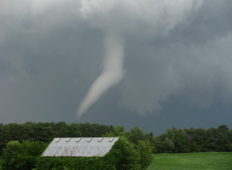
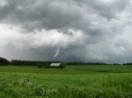
 Kiester Revisited. Yesterday a friend forwarded this amazing footage of the multi-vortex tornado that hit the Kiester, Minnesota area back on June 17. You can see 2-3 tornadoes, all rotating around a common center - something you'd expect to see in Kansas, not Minnesota.
 Drought Update. According to the U.S. Drought Monitor moderate to severe drought conditions linger over the Minnesota Arrowhead, but soil moisture is more than adequate across most of Minnesota. It's still too dry over the eastern suburbs of the Twin Cities and north of Brainerd. That may change by late tonight.
 Severe Clear. This high-res NASA (Terra) satellite image was taken around midday Friday, with 1000 meter resolution. What struck me (from an altitude of 220 miles) is the obvious impact of development, the urban sprawl around Chicago and Milwaukee, the string of towns showing up along the interstates. The patchy clouds just south of MSP mark a weak frontal boundary that went on to spark a few isolated severe storms later in the afternoon west of Rochester. The latest NASA "MODIS" image is here.
 A Real Sizzler. By now you know that 2010 is on track to be the warmest year since accurate weather records were first started in 1880, according to NOAA. A fluke or a trend? Click here to read a good summary of the hot weather gripping much of the northern hemisphere. More statistics from NOAA here.
 Typhoon "Conson" With winds of 75, "Conson" is a minimal typhoon (same thing as a hurricane) but it still poses a significant threat to southern China and Vietnam. The latest from the BBC is here.
 No More Vacation: How Technology Is Stealing Our Lives. O.K. This has nothing to do with weather, but it struck a cord with me. We have all these new fancy, high-tech ways of communicating, keeping in touch with friends, family (and the office). Technology was supposed to liberate us, instead it seems to be enslaving us. We can never fully disconnect from the grid - we have to get our information fix, we have to check our e-mail, tweets and FB posts, we can't possibly go a few hours without logging on and checking in. Somehow we've gotten to the point where everyone expects everyone else to be available, almost 24/7. "Why didn't you return my text?" Weekends, vacations - doesn't matter, we're all on-call, expected to drop everything and "stay connected" anytime, anywhere. Being "out of touch" has become a sin. How did we get to this place in time? I sense a backlash brewing - and I'm not the only one tempted to toss my "smart" phone into the nearest lake. A good summary of the problem from Salon here.
 Massive Tree Loss in the Amazon. A single violent storm may have brought down as many as a BILLION trees in the Amazon in 2005, researchers are reporting. This wasn't a hurricane, but a line of severe thunderstorms with unusually fierce straight-line winds, capable of bringing down 100-200 year old trees, more evidence that the frequency and intensity of severe local storms seems to be ticking up worldwide. The story from sciencedaily.com is here.
 Interactive Google Map Shows Possible Impact of 4 C Temperature Rise. Click here to see the potential effects of a 7-8 F temperature spike on the planet, a worst-case scenario by the year 2100, just about the time our grandkids walk outside, scratch their heads in wonder, and how they inherited such a mess. If you have Google Earth installed on your computer the KML file is here.
Slight Severe Risk (hot stormy Saturday, VERY nice Sunday)
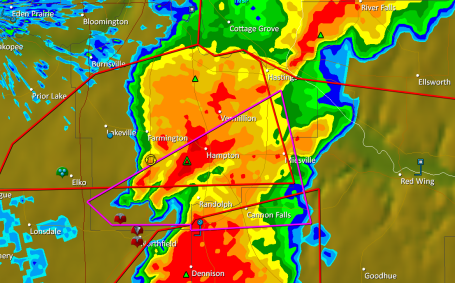
 Thumbprint of a Tornado. Tornadoes are too small to show up on Doppler, all we can do is track the parent thunderstorm. Storms that go on to spin up tornadoes also rotate, and this rotation shows up on the Doppler radar's velocity field. On Wednesday the NWS had not only evidence of extreme rotation, but confirmation on the ground from SKYWARN storm spotters nearby. The most accurate warnings have both components: Doppler radar + confirmation from trained professional spotters near the storm, confirming that the circulation is actually reaching the ground.
 Northfield Tornado. The camera was rolling when a tornado passed dangerously close to this storm chaser. Rated R for strong language. The CitizenTube clip is here.
 Wisconsin "Couplet". NWS Doppler radar from the Twin Cities (MPX) detected this vivid velocity couplet, indicating severe rotation just northwest of Ellsworth, Wisconsin, the tell-tale mark of a tornadic "supercell" storm.
 Hayward Aftermath. Was it a tornado or straight-line winds? Hard to tell looking at these damage pics, but whatever it was probably produced winds over 100 mph.
 No Complaints. Most of the state experienced a beautiful Thursday with bright sun, unlimited visibility, and a huge drop in humidity (dew points were in the 50s, meaning less than HALF as much water in the air than Wednesday). Highs ranged from 72 at Grand Marais to 85 in the Twin Cities, 86 at St. Cloud and Redwood Falls. Late-day convective showers and T-showers brushed far northern counties, the .79" of rain at Rochester fell shortly after midnight.
Weekend Summary:
Best Day: Sunday (mostly sunny, probably dry statewide with a slight drop in humidity). Winds: W/NW 10-20. Dew points: 55-65. Hours of rain: zero.
Saturday Storms: Much of Saturday will be dry, if you're outside during the morning, midday or early afternoon odds are in your favor. Watch for strong/severe storms by late afternoon/evening, and some of the storms Saturday night could produce flooding rains.
Winds: S 15-25 (gusty). Dew points: 65-70. Hours of rain: 2-5 (best chance at night).
Paul's Star Tribune Outlook for the Twin Cities and all of Minnesota
Today: Plenty of sun, warmer and more humid. Winds: W 10-15. High: 88
Friday night: Partly cloudy, slight chance of a T-storm over far southern MN, closer to the Iowa border. Low: 67
Saturday: Hot sun, windy and sticky. Strong/severe storms possible by late afternoon/evening. High: 91
Saturday night: T-storms likely, torrential rains possible, slight chance of flash flooding up north. Low: 71
Sunday: Sunnier, drier, slightly less humid - probably the nicer day of the weekend. High: 87
Monday: Partly sunny, isolated T-storm possible late. High: 86
Tuesday: Humid with more numerous/widespread T-storms likely. High: 85
Wednesday: Sunny and hot. High: 90
Thursday: Dog Days return, hazy sun, hot and humid. High: 92
Better. Much better. Thursday was summer the way it was probably meant to be: blue sky, reasonable humidity levels, a gentle breeze, afternoon temperatures within a notch or two of "normal" (whatever that is). It's the way I want to remember the Summer of '10. In stark contrast to Wednesday, which was the definition of "stinking hot", wild, throbbing clouds mutating overhead. "Partly sunny, with a slight chance of a tornado." Great.
Yesterday marked the midpoint of "meteorological summer", and you may be wondering how we're doing. No? Sorry, I'll try to offer a little perspective anyway. July is running more than 4 degrees F. warmer than average, after a June that run close to 1 F. warmer than normal. Based on cooling degree days (which you can think of as the deviation from 65 F, after you average the high and low for each day) shows that, since June 1, we've all spent about 22% more money than usual cooling our homes and businesses. The tornado count (still preliminary, based on 4 tornadoes Wednesday) stands at 37, although this could go up or down by 1 or 2 tornadoes once the local NWS comes out with their analysis of Wednesday's outbreak. The drought has eased over most of the state, with the exception of the MN Arrowhead, where moderate to severe drought conditions linger. Soil moisture is adequate across Minnesota's agricultural belt, farmers are in pretty good shape - no standing water in fields or massive hailstorms in recent weeks.
 Severe Saturday? Here we go again. I'm starting to sound like a broken record (skipping CD for anyone under the age of 30). Most of Minnesota is in a slight risk of isolated severe storms Saturday, the greatest potential for large hail, straight-line winds and even an isolated tornado or two coming over the southern half of Minnesota. The best chance of watches/warnings: after 4 pm Saturday.
We hang on to sunshine today, highs surging into the upper 80s to near 90 as winds swing around to the southeast, gusting over 20 mph at times by afternoon. The dreaded dew point begins to creep up again today, reaching 60 by midday - by tomorrow your favorite neighbor will be whining about the humidity one more time. All that water in the air will fuel yet another round of storms Saturday, the best chance of strong, potentially severe storms coming Saturday evening and Saturday night. In fact the models are hinting at some 2-4" rainfall amounts up north Saturday night with the possible formation of another MCS system, another mesoscale convective system bubbling up along a vigorous warm frontal boundary. I think most of Saturday will be sunny and hot with a gusty south wind, but have a Plan B (indoors) for late Saturday and Saturday night, when torrential downpours are possible. A wind shift to the northwest should shove the heaviest storms out of the state Sunday, the nicer, drier, sunnier day of the weekend.
 Saturday Downpours? The NAM/WRF model valid around midnight Saturday night (displaying predicted rainfall for the previous 6 hours) is hinting at heavy T-storms popping up late Saturday, possibly an MCS system capable of 2-4" rainfall amounts, the best chance of torrential rains over central and northern MN.
 Looks Like a Weekend. Models print out anywhere from .5 to over 3" of rain Saturday night. The chance of tropical deluges will probably be greater the farther north you go this weekend - I could see some flooding problems, especially across central and northern Minnesota. If you're camping try to avoid a site right next to a small stream - better yet take a battery-operated NOAA Weather Radio so you can hear the warnings, anytime, anywhere.
Hot Stuff. Next week looks seasonably warm, a string of 80-degree highs the first half of the week (more strong storms may fire off Tuesday of next week). Models are still hinting at more significant heat setting in the latter half of next week as a sprawling "heat-pump" high pressure bubble stalls over the Ohio Valley and the jet stream lifts well north, causing any cooling storms to detour across Saskatchewan, Manitoba and Ontario, Canada, leaving us hot and bothered. Highs could conceivably top 90 almost every day from next Wednesday or Thursday through the first few days of August. Great fun. I predict, more than ever, as we end the month of July the lake will beckon and the pool pass will become a necessity, not a luxury. We're due for some old fashioned heat, and it's on the way.
 Electrifying. The severe storms that swept across western Wisconsin Wednesday evening produced incredible amounts of lightning, nearly continuous cloud to ground strikes. See for yourself here.
 One Expensive Hailstorm. Check out this video of a severe hailstorm that shattered a greenhouse at the University of Calgary, Alberta. A few minutes of golf ball size hail caused an estimated $100,000 in damage, according to the Vancouver Sun.
 How Will a Hurricane Affect the Oil Spill? There's been a fair amount of speculation about what an (almost inevitable) hurricane in the Gulf of Mexico. Scientists are pretty much shooting in the dark - using computers to model the possible movement of oil. The bottom line, this has never happened before, so every scenario is speculative and theoretical, but this article does a good job summarizing the challenges involved. Rick Luettich, an oceanographer at the University of North Carolina, explains the complexities of trying to model the impact here.
* Hurricane Intensity Forecasts May Never Be Feasible. The story is here.
 Big Numbers. With any luck the BP engineers successfully capped the Deepwater Horizon well on Thursday, but even if they pull off this engineering feat, the amount of oil that's been released into the Gulf of Mexico is staggering. The latest estimates here.
 Sea Levels Rising in the Indian Ocean. So much for greenhouse effect "theory", rising sea levels are impacting countries from the Bay of Bengal to Java, and rising CO2 levels are at least partly to blame. The story is here.
 2010: Warmest First Half of the Year on Record. All 10 of the warmest years (worldwide) have occurred in the last 15 years, according to NOAA. At the rate we're going 2010 could edge out 2005 for the warmest year ever observed. We've already surpassed 1998 for the most "warmest months" in a calendar year. Arctic sea ice is 10.6% less than the 1979-2000 average, but (oddly) Antarctic ice is greater than average. A complicated puzzle indeed, but you can read a good recap of the latest findings from msnbc.com here.
 Proof that Vodka and Extreme Heat Don't Mix. This is actually a tragic story: an estimated 200 drowning deaths in Russia have been blamed on overheated (drunk) people trying to find relief in swimming pools and lakes - with tragic consequences. The unbelievable story is here.
Wild Wednesday Recap (and hints of a real heat wave starting next week)
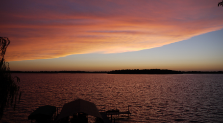
A Fine Finish. This photo, taken around 9 pm last night, shows the setting sun illuminating the underside of a massive T-storm anvil spreading north from storms bubbling up over extreme southeastern Minnesota. Amazing.
Paul's Star Tribune Outlook for the Twin Cities and all of Minnesota
Today: Mostly sunny, breezy and pleasant (a big drop in humidity from yesterday). Winds: W/NW 15-25. High: 84
Thursday night: Clear and comfortable. Low: 66
Friday: Sunny, heating up again. High: 88
Saturday: Hazy sun, sticky and hot with a stiff south wind. T-storms possible late, especially central and northern MN. Winds: S 10-20+ High: near 90
Sunday: Drier and sunnier with a slight dip in humidity - probably dry. Winds: W/NW 10-15+ High: 87
Monday: Lot's of sun, beautiful. High: 85
Tuesday: Partly sunny and seasonably warm. High: 86
Wednesday: Blue sky, sticky and plenty hot. High: 91
What a day. You survived/endured one of the more unusual days of the summer - a free sauna in the comfort of your own back yard, coupled with a turbulent, violent sky mutating, minute by minute, overhead. Blast-furnace levels of heat and humidity (at one point the heat index in Fairmont reached an unimaginable 113 F - that's what it FELT like across far southern Minnesota). The dreaded dew point reached 78 at MSP and St. Cloud, over 80 from New Ulm to Rochester, similar to the humidity levels one might encounter in Abu Dhabi or the Philippines. Heat advisories, tornado watches and warnings - all capped off by an awe-inspiring sunset, the result of a massive thunderstorm anvil spreading north into the metro area, a thunderstorm helmet illuminated by the setting sun.
 Wednesday Madness. Highs reached 93 at St. Cloud, the Twin Cities and Redwood Falls, 01 at Rochester (where the dew point topped 80). Rainfall amounts reached nearly 2" at Grand Marais, only .08" at St. Cloud and .27" in the Twin Cities.
A few atmospheric low-lights:
* 93 degree high in the Twin Cities Wednesday, 5th day above 90 this year (but factoring in a dew point of 77-78 F it FELT more like 100-105 around late afternoon).
* Heat index of 113 reported at Fairmont, dew point reaches 81 (!)
* At least 5 tornado touchdowns from Wednesday's storms, possibly more.
* 38 tornadoes so far in 2010 in Minnesota? As of Tuesday Pete Boulay from the MN State Climate Office reported a running tally of 33 tornadoes + 5 (preliminary) tornadoes yesterday.
* Reports of 4"+ rains in Barron county, Wisconsin on Wednesday.

Tornado Reports. SPC reports at least 4 separate tornado touchdowns, near Lakeville, Randolph, Northfield, and Cloverdale, up in Pine County. More possible tornadoes were spotted in western Wisconsin, the local NWS office in Chanhassen is dispatching a damage assessment team Thursday to determine the size and scope of these tornadoes - expect preliminary findings as early as Friday. See the latest reports from SPC here.
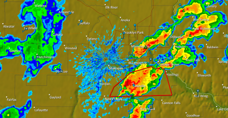
 Touchdowns. Storm reports are automatically plotted on the "GR2 Analyst" software from Gibson Ridge. The main zone of tornado reports (and subsequent damage) was between Lakeville and Northfield, between 2 and 3 pm. The south metro went from blue sky to tornadic "supercell" thunderstorms in less than 45 minutes.
 Wednesday Storm Reports. The NWS reported 4 touchdowns near Lakeville/Northfield, another in Pine County, with an additional 5 tornadoes reported across western Wisconsin. Click here for a detailed text report of all the severe storm reports out of the MPX office.
On Monday and Tuesday we tried to pinpoint the counties of Minnesota most likely to experience tornadic thunderstorms, and the models (coupled with gut feel) worked pretty well. On Tuesday we predicted the greatest risk would be "just south/east of the Twin Cities, probably east of I-35". It's impossible to predict tornadoes more than 30-60 minutes in advance, but all in all the forecast worked out pretty well (relieved that there were no reports of injuries or widespread damage, although we won't know the full extent of damage until teams arrive on the scene).
It was a turbulent Wednesday, no question. The day started with an MCS (mesoscale convective system) arriving, right no schedule, sweeping across central and northern Minnesota during the early morning hours, whipping up 2-3" rains, frequent lightning and winds over 50 mph. After a brief pause the main event kicked in shortly after 2 pm, a combination of extreme instability, wind shear and dew points near 80 sparking explosive thunderstorm development just south of the metro area - Northfield and Lakeville hardest hit, reports of vehicles swept across highways and damage to some homes and barns. Funnels were spotted near Glenwood, a lowering, rotating wall cloud causing quite a stir near Sauk Center, sparking more funnels north of St. Cloud between 3 and 4 pm. More severe storm watches were posted, but by that time winds were already swinging around to the west, drier air sweeping the worst of the storms across southeastern MN into Wisconsin.


Rainfall Recap. The first batch of storms that swept across central and northern MN Wednesday morning dropped some 1.5 to 2" rainfall amounts from near Wadena to Brainerd to Sandstone. The severe storms that erupted during the afternoon dumped even heavier amounts of rain on extreme southeastern MN and western WI, Doppler radar estimates suggesting some 3" amounts near Wabasha, maybe as much as 5-6" closer to Black River Falls, Wisconsin.
So now we exhale, enjoy a couple of phenomenal days, blue sky, more reasonable humidity levels (dew points in the 50s have never felt better) and wait for another warm-up coming Saturday. The weekend looks pretty good right now, hardly meteorological perfection (it's 'gonna be stinking hot on Saturday with a gusty south wind, maybe a few late-day and nighttime storms, especially up north). Sunday looks better, drier statewide, and just a couple degrees cooler. But the vast majority of the weekend should be dry - perfect weather to check out the Hopkins Raspberry Festival, or the million and one other things to do around the state.
How (on earth) did it get to be "mid summer"? That's the problem with our fleeting warm weather season here in Minnesota, if you blink, sneeze, change the channel, it's already Minnesota State Fair Time, you're already being annoyed with back-to-school commercials. Please let time stand still for a few more weeks...
 "Heat-pump High" Long-range models show an expansive bubble of high pressure temporarily stalling over the Ohio Valley the latter half of next week, forcing the main belt of westerlies, the core of the jet stream, north of Minnesota. The result? As many as 7-12 days or more of highs above 90 from roughly July 21 through the first few days of August. We're due for an extended stretch of heat, and it's finally showing up on the maps. To track the progression of the 500 mb winds (roughly 19,000 feet above the ground) over the next 10 days, click here (data courtesy of Unisys).
Now, at the risk of burying the lead, news of impending heat. We've been pretty lucky so far, just a few brief, fleeting glimpses of summer heat, nothing prolonged (or controversial). That may change next week. The GFS model is strongly hinting at 1-2 weeks of 90s, starting next Wednesday, going through the end of July, possibly the first few days of August. That's hardly surprising, considering our hottest weather routinely comes in late July. Enjoy today's slightly-cooler-front - I have a hunch with 8-10 days friends, neighbors, colleagues will all be griping about the Dog Days of Summer (in unison). Something to look forward to huh?
 Hammond, Wisconsin Damage. Here is a YouTube clip showing one example of the wind damage from recent storms in Hammond, impossible to tell if it was straight-line winds or tornadic.
 Typhoon Conson. Here is footage from the recent typhoon (same thing as a hurricane) that slammed into the Philippines, causing massive flooding.
 Daily Oil Impact Assessment. If you're interested in a blow-by-blow, day-by-day accounting of clean-up efforts in the Gulf click here to see the very latest initiatives and projects underway.
 GeoPlatform.gov. Another tracking tool, showing fishing closures, the size and direction of the spill - an amazing interactive site that packs in a lot of relevant, current information.
 Tracking Ocean Currents in the Gulf of Mexico. Here is a link explaining the intricate currents in the Gulf, and the possible impact on the growing oil slick - where will it go next?
 Oily Waters - Is NOAA Hoarding Key Data On Oil Spill Damage? It appears that real-time observations from the Gulf (above and below sea level) are getting to BP much faster than they're getting out to the general public. An interesting development here.
Severe Storm Risk Eases - Cooler, More Comfortable Front Arrives
* Heat Advisory. The local NWS office has issued a "Heat Advisory" for much of southern/eastern MN, highs near 90 today coupled with dew points in the mid 70s may create a heat index in the 100-105 F. range this afternoon. Slow down, drink plenty of fluids, check in on the elderly and infants - most at risk of extreme heat (and humidity).
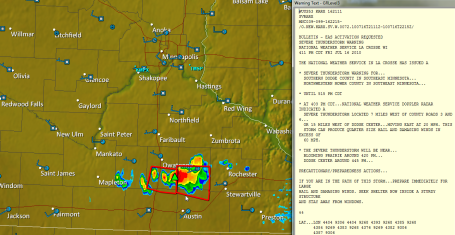
 Significant Severe Threat. SPC has a 45% hash mark over southeastern Minnesota and southwest Wisconsin, meaning a 45% risk of severe storms within 25 miles of any town in the purple-shaded region. The atmosphere floating over Minnesota will be volatile much of the day, but the greatest risk of hail, damaging straight-line winds and isolated tornadoes appears to be east of I-35, probably south/east of the Twin Cities. The latest from SPC is here.
Paul's Star Tribune Outlook for the Twin Cities and all of Minnesota
Today: Very humid, windy and warm with T-storms likely (best chance early, again this afternoon). Some midday sun is possible, and storms redeveloping this afternoon will probably be severe. A few isolated storms may produce large, damaging hail and isolated tornadoes - watches and warnings are likely later today. Stay alert for rapidly changing conditions). Wind: S 15-25. High: 87
Wednesday night: Evening T-storms (best chance southeastern MN and western WI). Clearing late. Low: 64
Thursday: Mostly sunny, warm and dry. High: 84
Friday: Blue sky, seasonably warm. High: 87
Saturday: Partly sunny, hazy and humid with a stiff south wind (15-25 mph). T-storms are possible late in the day and at night, especially over northern & central MN). High: near 90
Sunday: Plenty of sun - an isolated storm can't be ruled out, but most of the day should be dry. High: 86
Monday: Sunny start, then increasing clouds, T-storms arrive late. High: 84
Tuesday: More clouds than sun, still humid. High: 86
Welcome to a potential wild Wednesday. Many of the ingredients are present for a severe weather outbreak, but (as always) there are a few meteorological wild cards. If clouds persist that will limit surface heating and (greatly) lower the risk of severe storms erupting this afternoon. The longer the sun is out during the midday/early afternoon hours the greater the potential for some rough storms popping after 3 pm or so. Any early-morning rain will cool & stabilize the atmosphere, also lowering the risk of severe storms later in the day. Morning storms will create "outflow boundaries" (sort of like miniature cool fronts). Any afternoon storms will probably be initiated along these boundaries, but trying to determine precisely where these boundaries will set up is next to impossible.
 Tuesday Touchdown. Late Tuesday there was a reported tornado touchdown 7 miles east of Georgetown, in Clay county - a funnel cloud observed near the town of Christine, in Wilkin county, very close to the Dakota border. At least 33-34 tornadoes have formed in the skies above Minnesota so far this year, well above the yearly average of 25-30 that normally touch down.
The level of granularity and precision necessary to pin down EXACTLY which counties will get roughed up the most is beyond the scope of the NOAA computer models we use to predict the weather. These "micro-meteorology" events literally fall between the cracks, a 5-10 mile diameter "supercell" thunderstorm much too small to show up on the simulations we look at (where the predictions are spaced 20-40 miles apart). I've said it before, I'll mumble it one more time, predicting when/where a tornado will touch down is like you telling me (right now) where/when you'll sneeze this afternoon. Good luck with that. All we can do is tell when conditions are ripe for tornadoes.
Today we have many of the necessary ingredients:
 80-Degree Dew Point? The NAM/WRF model brings 80-degree dew point air into far southeastern MN Wednesday afternoon, off-the-scale levels of humidity that may provide the necessary fuel for a severe storm outbreak later in the day. Data courtesy of twisterdata.com.
1). Low-level moisture (translation: sticky, icky air direct from the Gulf of Mexico). The higher the dew point, the more moisture in the air. The NAM/WRF model is hinting at dew points in the mid 70s by midday. To put that into perspective, a dew point of 60 is considered humid, 70 is tropical/unbearable, once every couple of years we'll see a fleeting dew point of 80, which is unbearable (and potentially life-threatening).
 Tornadic Thumbprint? This is a "hodograph" plot. Although the graphic looks vaguely incomprehensible, the red line shows the predicted change in wind direction with altitude for a hypothetical weather balloon rising above Rochester, MN around lunchtime today. Winds are forecast to "veer" with altitude, going from southerly near the ground to southwesterly a few thousand feet above the ground, to westerly at 10,000 feet. This "wind shear" may be sufficient to create a ripe environment for "supercell" T-storms, capable of large, damaging hail and isolated tornadoes, especially south/east of the Twin Cities metro area. For more on hodographs click here.
2). Wind Shear. When winds are not only strong, but shifting direction and speed (turning more clockwise with altitude) then conditions are ripe for horizontal wind shear to be "tilted and stretched" about a vertical axis. A violent thunderstorm updraft can transform this horizontally spinning air into a narrow column of rapidly spinning air shooting straight up at 100 mph. or more. Wind shear also allows T-storms to tilt over (slightly), protecting the warm updraft, preventing a thunderstorm from self-destructing as rain & hail-cooled air wraps into the updraft and kills the storm. These "unprotected updrafts" are prime candidates for storms that may eventually go on to spawn large, damaging hail and tornadoes. Today low-level winds will strong and shifting with altitude, creating a perfect environment for rotating "supercell" thunderstorms capable of tornadoes.
 3). Sounding. Here is the NAM/WRF "sounding" valid for the Rochester, MN area around midday today, showing an "inversion" around 850 mb, roughly 3,000-4,000 feet above the ground (temperatures temporarily warming with altitude), what meteorologists call a "cap". Once warm thermals break through the cap the sounding hints at rapid, perhaps explosive growth of T-storms by mid afternoon). Data courtesy of twisterdata.com.
4). Instability. Temperatures almost always cool with altitude, but a "capped" environment can inhibit T-storm growth - an inversion (a warmer layer of air thousands of feet overhead) can act like a brake on rising thermals of warm air, preventing storms from firing. But if there's enough upward motion, an approaching storm aloft (or surface heating) this "cap" can be overcome. Once the updraft breaks through the inversion storms can mushroom in minutes. But to get tornadic storms you not only need buoyancy, but shear, and today we seem to have both ingredients.
I know - more than you wanted to know about "tornadogenesis." But I'm hoping that a sufficient number of readers checking in want to more know that just the basics, so I'll err on the side of providing TOO much background information. For more on tornadoes check out this excellent FAQ page from SPC, the Storm Prediction Center (the government division of NOAA that issues watches for the entire USA).

Tornado Tip-offs:
If you see any of the following, it's time to head for the basement (or any other sturdy shelter), even if there are no warnings, and the sirens aren't going off.
1). Large Hail. Any thunderstorm updraft violent enough to keep golfball to baseball size hail several miles aloft is potentially strong enough to spin up a tornado. I usually don't get nervous until/unless large hail begins to fall.
2). Greenish Sky. You've heard this one before - if the sky turns an eerie shade of green or yellow, time to head for the basement. Meteorologists don't completely understand why the sky turns a sickly shade of green before a tornado - it may have something to do with white sunlight being refracted as it passes through a cloud of hail towering overhead.
3). Rotating Wall Cloud. A tornado usually forms on the southwestern flank of a severe thunderstorm. Rain gives way to large hail, skies may brighten before the tornado moves through. Watch for any lowering, rotating cloud base - here is where a tornado is most likely to form, on the edge of the updraft.
* Remember, the outdoor emergency sirens were NEVER meant to be heard indoors. They are for outdoor use only. The secret to weathering Minnesota's manic, occasionally violent weather, is to have multiple safety nets: TV, radio, web, cell phone alerts, and the best (cheapest) life insurance you'll ever buy: NOAA Weather Radio, which can be set up to sound an alarm for only your county when a warning is issued.

Where Should You Go?
* At Home: A basement is still your safest bet, under the stairs, under a heavy piece of furniture, like a table or desk (if available). You don't want to hide in the southwest corner, statistics show that the safest place is under the stairs.
* No Basement? No worries. You're still relatively safe if you can find a small, interior room, like a closet or bathroom. Avoid outer walls and windows. People have survived F-5 tornadoes by going into their bathtubs, reinforced by pipes - it's usually the last thing to become airborne.
* Office. Avoid elevators if a tornado warning is issued, find a (concrete-reinforced) interior stairwell - OR - an interior bathroom. Again, avoid outer walls and windows. There's little risk of the office tower collapsing, the real risk (as is always the case) is being hit by flying debris. A tornado is a giant swirling landfill. The danger is not getting sucked up into the heavens like Dorothy in the "Wizard of Oz." The real risk is standing up and being hit on the head by a little rock, nail or other piece of debris, turned into a missile, a projectile by 100-200 mph. winds.
* In a Vehicle. If you can't outrun the tornado or find a building/store/building nearby, get out of your car or truck and seek shelter in the nearest ditch. Curl up in a ball and try to stay as low as possible. Do NOT hide under a bridge overpass (this actually increases the threat of being hit by flying debris). Don't hide under or in your vehicle, which can become airborne once winds top 90-100 mph.
Enough tornado-babble and Doppler-speak for one day - just know that it may be an "active" day. Expect watches and warnings later today, go about your normal activities, but keep an eye on the sky and stay tuned for updates. As I tell my kids (without freaking them out) it's all about situational awareness. Keep asking yourself: what would you do, where would you go if a tornado was sighted right NOW? Have a continuous action plan, just in case. Chances are (very) good you'll never need to use that plan, but my Boy Scout days come to mind, summed up in two words. "Be prepared."
Good news: after today's fireworks things settle down Thursday, as winds turn around to the west, pumping drier air into Minnesota. Under sunny skies temperatures reach the 80s Thursday and Friday, in fact blue sky should linger into most of Saturday, as winds begin to blow from the south, pumping sticky air back into town just in time for the weekend, setting the stage for more scattered T-storms late Saturday and Saturday night (especially up north). Models are still hinting at a string of 90s the latter half of next week. Enjoy our relatively "comfortable" weather this week - next week may bring the Dog Days of Summer - finally.
 Heat Wave Next Week? The CPC, Climate Prediction Center, is predicting temperatures well above average from July 21-27. We may experience a string of 90-degree days, especially the latter half of next week.
 8 Injured as German Tornado Hits North Sea Island. After nearly 100-degree heat severe storms ripped across much of Europe late Monday, producing rare tornadoes. The story is here.
 Long-Range Outlook: More Heat. The frequency and intensity of heatwaves is forecast to increase in the coming decades - more on the reasons behind the forecast of escalating heat here.
 12 Month Running Mean Global Temperature Has Reached a New Record in 2010. The latest data from NASA here.
* Climate Change Needs a Plain English Guide. Amen to that. The story is here.
* Scientists Quantify Global Warming's Threat to Public Health. Here is the story in Scientific American
 Study: Global Warming Could Negatively Impact Yellowstone Ecosystem. Climate change isn't a theory - it's already taking place, evidence on display at one of America's most cherished national parks. More from the yellowstoneinsider.com here.
Tornado Warnings Far Western MN

Paul's Star Tribune Outlook for the Twin Cities and all of Minnesota
Today: Sun dimmed by high clouds, warmer, more humid than yesterday. Severe storms push into far western MN by late afternoon or evening. Winds: S/SE 15-25. High: 84
Tuesday night: T-storms arrive, some packing heavy rain and frequent lightning. Low: 71
Wednesday: Muggy and unsettled with intervals of sun, a few severe storms are likely by late afternoon, with a significant risk of large hail, damaging winds, even a few tornadoes. High: 83
Thursday: Getting sunnier, drying out statewide. High: 86
Friday: Blue sky, plenty warm. High: 88
Saturday: Probably the sunnier day of the weekend - partly sunny, windy and humid. High: 89
Sunday: Less sun, a few scattered T-storms likely. Sticky. High: near 90
Monday: Partly sunny, an isolated T-shower possible by late afternoon. High: 86
 Monday Miracle. This is the first time I can recall seeing this all summer: no rain at any reporting station in Minnesota, highs fairly uniform, ranging from 75 at Alexandria to 80 at Crystal (northwest suburb of Minneapolis).
Have we had a bad Monday yet far this summer? I doubt it. Mondays always seem to be sunny and nearly trouble-free, and today was no exception, with morning clouds giving way to blue sky and low humidity. Dew points dipped into the 40s and low 50s as much drier air leaked south out of Canada, a welcome respite from the thick humidity of last weekend. I must be mad - I spent most of yesterday evening sitting out on the deck, watching the setting sun, reading a barbell of a book, Stephen Kings "Under The Dome", which weighs in at 5 pounds and 1074 pages. Not so much of a novel as a workout. That's how I want to remember the summer, sitting under a molten sun, reading (for pleasure) and temporarily putting the cares and worries of the day into a drawer. I know, easier said than done.
 Reverse Lake Effect. Here is NASA's ultra-high-res visible satellite image taken midday Monday, showing a lack of clouds over lakes across Minnesota and Wisconsin. The reason? Lake water temperatures are relatively cool (50s over Lake Superior to 70s from Leech to Mille Lacs). In contrast surrounding land areas are warmer by 10-15 degrees, sparking thermals of warm, rising air and subsequent "popcorn" cumulus clouds. It's the reverse of what happens in the late fall and early winter months, when lakes are warmer than surrounding land masses, sparking clouds and showers of rain/snow downwind, especially over the larger Great Lakes, where the "fetch" of wind over the lake is long enough to spark precipitation. The latest MODIS image can be found here.
* Great Lake Warms Up. The top waters of Lake Superior just reached an average temperature of 59 F, more than one month ahead of schedule. The story in the Star Tribune is here.
 Severe Threat. Strong/severe storms will bubble up over the Dakotas later today, reaching far western Minnesota by the dinner hour, some capable of large, damaging hail, straight-line winds even an isolated tornado. Storms may still be at or near severe levels by the time they reach the St. Cloud area after 8 pm. The very latest from SPC (Storm Prediction Center) can be found here.
Wednesday looks ripe for trouble, so much so that we're sending one of our brave WeatherNation interns out to chase tornadic "supercell" storms - equipped with an HD camera, wireless card and laptop. That's how nasty we think Wednesday may be - most of the ingredients necessary to whip up tornadoes probably present nearby: unusually strong low-level jet stream winds (as high as 30-50 mph. in the lowest few thousand feet of the atmosphere), ample low-level moisture (dew points near 70) and explosive instability. If the sun is out for a few hours during the midday and early afternoon hours Wednesday (a distinct possibility) then severe weather is almost a sure thing. The big question: will Tuesday night/Wednesday morning T-storms stabilize the atmosphere and push the main threat south/east of Minnesota (possible, but doubtful). If clouds linger much of the day warm, rising thermals of juicy air may not be able to break through the "cap", an inversion of warming air a few thousand feet aloft. There are no guarantees (there never are) but I'm sufficiently paranoid about Wednesday that I'm going out on a (shaky) limb, predicting a minimum of 3-6 tornadoes - best chance south of the Minnesota River. I hope I'm wrong - but I fear that a witch's brew of ingredients may converge directly overhead Wednesday afternoon and evening. Plan on watches and warnings, have a Plan B and C after lunchtime on Wednesday, and be pleasantly surprised if tornadic storms don't materialize.
We hang on to a blue sky much of today, gusty south winds by afternoon pumping stickier air back into Minnesota, late afternoon temperatures reaching the mid 80s as high (cirrus) clouds dim the sun. There's a slight risk of severe storms sweeping into far western Minnesota later this afternoon and evening, possibly forming an MCS system (mesoscale convective system) tonight as it weakens over central and eastern MN, capable of frequent lightning and torrential rains. There's a good chance we'll get off to a soggy start Wednesday morning, but I expect the sun to peek through by midday, setting the stage for a potentially widespread severe storm outbreak later Wednesday, possibly the biggest outbreak since June 17, when over two dozen tornadoes touched down on Minnesota, the second greatest outbreak in Minnesota history. We'll see, but I have a pretty bad feeling about tomorrow.
Skies clear Thursday, sunshine the rule Thursday through Saturday, which (right now) looks like the sunnier day of the weekend. Right on cue, right on schedule, here comes another noisy front Saturday night and Sunday, another outbreak of T-storms likely. Best chance of being chased indoors by churning black clouds? Saturday night, again Sunday afternoon.
We're due for a little real heat, a spell of sweltering, sweaty weather, a string of 90s. The GFS is hinting at 4-5 days in a row above 90 the latter half of next week, and frankly, I wouldn't be one bit surprised. Historically, Minnesota's hottest weather comes 3-4 weeks AFTER the summer solstice, usually in mid or late July. We've had only 4 days above 90 (typical summer brings 13 or 14 days at or above 90). We're due. Stay tuned, and check in often over the next 24 hours as we try to pin down which counties in Minnesota may see the worst of Wednesday's severe storm outbreak (my hunch is Mankato to Rochester, but this could change, depending on a myriad of factors).
If severe (tornadic) storms do develop Wednesday afternoon we'll be tracking them right here at startribune.com - making it easy to check in on your computer from work or home. I have a hunch the Doppler is going to be smoking within 24-36 hours.
 A Hint of Real Heat? The GFS model is suggesting 4-5 days in a row above 90 the latter half of next week. We're due, and it's coming at the right time (our hottest weather of the entire year often comes during the second, third or fourth week of July).
 Full Moon Over Minneapolis. Click here for a photogenic timelapse of the recent full moon over the Twin Cities, courtesy of Brian Stuckey and Vimeo.
 Fewer Tornado Deaths in 2010. Kansas.com has an interesting article about the relatively low number of Americans that have been killed by tornadoes so far this year. Luck? Doppler radar? More professional storm spotters? Perhaps a combination of all three. The article is here.
 Shelf Cloud - Belgian Style. America sees more severe storms than any other nation on Earth, but we certainly aren't the only ones capable of seeing rough T-storms capable of strong, straight-line winds, like the squall line that raged across Brussels, Belgium last weekend. The video timelapse is here.
 Images BP Doesn't Want You To See. The Atlantic has the story, and a series of disturbing photos here.
Climate Stories
 Earth From Space: Greenland Glacier Shrinks Overnight. Between July 6-7 a 2.7 square mile chunk of a Greenland glacier broke off, roughly 1/8th the size of Manhattan Island. The story at Wired News is here.
* Scientists Find Rising Carbon Dioxide And Acidified Waters in Puget Sound. Click here to read the full text of the story from NOAA.
* Hawaii is Already Feeling The Effects of Global Warming, Experts Say. The story is here.
* If You Can't Stand the Heat, You Won't Like This Study. The article is here.
* We Fiddle, While the Farm Belt Copes With Climate Change. Most farmers will tell you that something has changed, the rainfall and temperature patterns have changed in recent years, not as reliable (or predictable) as they were for much of the 20th century. The story at chron.com is here.
Wednesday Tornado Threat
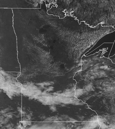
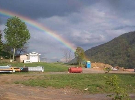
 Cars + Kids + Heat = Trouble. Don't even think about leaving a child in a hot car this time of year, even for a few seconds. The statistics are frightening - under a hot, summer sun the interior of a car can heat up to 120 F or higher in only a few minutes - more details on the threat posed by leaving kids in hot cars is here.
 Worse Than Texting-While-Driving? Yesterday I was paging through one of those "Skymall" magazines on the Delta flight, and I came across this product. I think I let out a little scream (other passengers were staring) but I honestly couldn't help myself. Can you imagine driving behind this gal as she checks her e-mail from the front of her massive Suburban? My favorite part of the photo - the little printer. How is this even legal? God help us all.
Paul's Star Tribune Outlook for the Twin Cities and all of Minnesota
Today: Patchy clouds early, then plenty of sun with a welcome drop in humidity. Winds: E 8-13. High: 79
Monday night: Mostly clear and comfortable. Low: 62
Tuesday: Plenty of sun, warming up again. High: 84
Wednesday: Unsettled with T-storms likely, locally heavy rain possible. High: 82
Thursday: A mix of clouds and sun, seasonably warm. High: 86
Friday: Hot sun, sticky. High: near 90
Saturday: Hazy sun much of the day, still plenty warm. A few T-storms possible late Saturday, likely Saturday night. High: 89
Sunday: Partly sunny, a passing T-storm possible (mainly far southern MN and WI). Most of the day will probably be dry. High: 85
 Sunday Almanac. A slightly cooler, drier front ignited more storms, with the heaviest rains observed over southern MN (.47" at Rochester and .74" at Redwood Falls). St. Cloud picked up only a trace of rain with a pleasant high of 83. Farther down I-94 .17" fell on the Twin Cities, International Falls only reached a high of 73 with .12" of rain.
 Squall Line. Flying into MSP from BWI (Baltimore) Sunday afternoon we flew around a building line of cumulonimbus, thunderstorms flaring up just south/east of the Twin Cities. These towering thunderheads went on to spark 1" diameter hail near Rochester around the dinner hour.
How is it Monday already? What happened - where did the weekend go? Don't you wish you could slow down time on Saturdays and Sundays, just hit "pause" on the old remote control and replay every minute (when it's not raining cats, dogs and canaries). At least the sun was out most of the weekend, respectable 80s, noticeable humidity levels, but nothing outrageous. It was a classic summer weekend across Minnesota, more sun than thunder, plenty of quality time to romp on the lake and make some summer memories.
 Stormy Wednesday. Models print out anywhere frm .4 to over 1.5" of rain Wednesday. Dry weather persists today and most of Tuesday, but batten down the hatches around midweek.
Yesterday's storms are long gone, a puff of slightly cooler, drier Canadian air sweeping the storms towards Chicago - you'll feel a welcome drop in humidity today with highs holding in the 70s across most of Minnesota. Blue sky lingers into much of Tuesday as temperatures warm a few degrees, back up to "normal". The next chance of showers and t-storms comes Wednesday, more storms and potential downpours before we dry out again Thursday and much of Friday. These fronts are spaced out every 2-3 days, which means (right on schedule) more scattered T-storms over the weekend, the best chance Saturday night. The good news: weather systems are progressive (ie, they're moving along at 15-25 mph, no signs of stalling out, prolonging the rain for most of the weekend). It's early, but right now y hunch is that next weekend will be vaguely similar to this past weekend, plenty of warm sun interrupted by a few hours of showers and T-storms.
 Sticky Saturday. I can't help myself - already scanning the maps, pondering next weekend's weather. How the heck is it already MID summer? The GFS model is hinting at a warm, humid, southerly wind flow with T-storms rumbling into far western MN late Saturday, possibly reaching central and eastern MN Saturday night. Most of the weekend will probably be dry, but plan on dodging more scattered T-storms. With any luck most of the rain will come Saturday night.
I'm just back from out east (gave a speech about my entrepreneurial misadventures at Penn State's 75th anniversary of their meteorology program). Somewhere between 1 in 4 and 1 in 5 meteorologists in the USA is a Penn State grad - not sure what's in the water in central Pennsylvania that makes otherwise sane people want to tackle the vagaries of the weather, but I was happy to be there, encouraging others to take the plunge and consider starting their own companies. That old saying, "everyone has at least one book in them?" I firmly believe that just about everyone has at least one company in them. The one thing most people lack? Confidence. The beauty of today (vs. 30 years ago) is the rise of the Internet, the ability to set up a "stealth" company on the side, keep your day job until/unless your little hobby on the side takes off and bears fruit. With the 'net it's never been easier to take an idea, fine-tune it, and turn it into a business. If you're pondering doing just that, good luck. You may surprise yourself what you're capable of. Don't listen to the naysayers. If you're flexible, adaptable, and most of all - tenacious - you can find a way to turn your hobby, your passion, into a business. There's nothing more exhilarating than turning a concept into a company. You'll need people who compliment your skills, smart people with can-do mindsets. They're out there, in fact that's one (of many) reasons why I stayed in Minnesota. There are a lot of smart, ambitious (honest) people out there who just need some direction, a vision.
Enjoy what should turn out to be a memorable Monday, weatherwise. Soak it up, because chances are all be making a mad dash in about 40-48 hours as the next (noisy) line of weather moves through these parts...
Star Tribune Print Weather Column
"Breathing easier"
I just returned from the D.C. area, got a chance to sample the 100+ heat last week. You have to remember that our nation's capital was built on swampland that neither Maryland or Virginia wanted. D.C. is to heat what International Falls is to cold. It's hard to describe the sensation, but here are some of the comments I heard. "Feels like I'm locked in a sauna. This is what it must feel like to drown in a hot tub. I'm taking in deep breaths, but not getting any air!" It felt like a perpetual sunburn as locals dashed from one air conditioned space to another.
Glad to be home, where skies have cleared, a fresh Canadian breeze promises blue sky & a welcome dip in humidity - 48 hours to dry out. The next batch of storms arrive Wednesday, followed by a run of sunny, hot weather late in the week. Long range (GFS) models are hinting that most of the thundery weather may be suppressed just to our south, over Iowa, much of next weekend, skies sunnier the farther north you go, highs from 85-90 F.
June was the 8th warmest on record nationwide, according to NOAA. 387 June tornadoes were reported, the 2nd most on record; nearly 30 of those twisters touching down right here on Minnesota.
 8th Warmest June on Record. NOAA has all the details here.
Hot Weather in a Warming Climate. Is it "weather" or "climate"? Some interesting thoughts and observations here.
Study: U.S. To Fell More Heat, More Often In Coming Years. Although no one heatwave, storm or other weather event can be directly linked to climate change, the tempo and frequency of these events is forecast to increase in a warmer world. The story is here.
 Study: Long Heatwaves Could Be Common in U.S. by 2039. If climate change theory is correct, then the kind of long-lasting 100-degree heat that gripped much of the northeast last week may become more commonplace in the years ahead. The story is here.
No comments:
Post a Comment