Super typhoon Haiyan hits Category 5, an extremely serious threat to Philippines

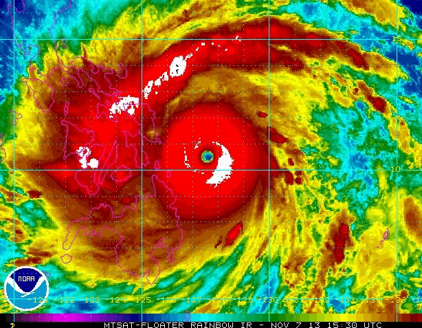
Super typhoon Haiyan at 17:30 UTC or 12:30 p.m. EST Wednesday (NOAA)
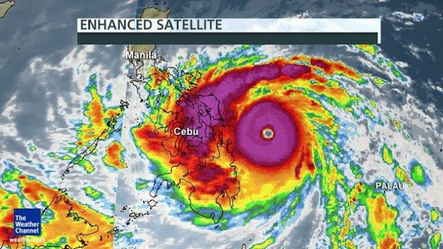
The western Pacific storm Haiyan has intensified without interruption since Sunday and is now a dangerous Category 5 super typhoon, with maximum sustained winds exceeding 160 mph. It is on a path due west, and landfall Friday in the central Philippines is inevitable.
Haiyan – known as Yolanda in the Philippines – is likely the strongest storm to form on the planet this year.
“Based on satellite imagery, [Haiyan's] the strongest storm I’ve seen since Bopha (2012),” says Ryan Maue, a meteorologist with WeatherBell Analytics.
Super typhoon Bopha, whose peak winds reached 175 mph, caused hundreds of fatalities on the southern Philippine island of Mindanao in December 2012.
Maue says it’s possible Haiyan’s maximum sustained winds have reached 180 mph.
“[The] system has developed to almost max intensity for a cyclone,” notes a NOAA bulletin.
Officially, the Joint Typhoon Warning Center forecasts additional strengthening over the next day, but with the storm near its theoretical maximum strength – it’s more likely it has leveled off. As it continues westward over the Philippine Sea, its inner core may re-organize through what’s known as an eyewall replacement cycle, which would briefly weaken the storm. But water temperatures are very warm along Haiyan’s path, so significant weakening is unlikely.

At landfall – predicted to occur around 0-6 UTC Friday (Friday morning local time in Manila) – the storm is forecast to have maximum sustained winds around 155 mph – equivalent to a high-end category 4 hurricane.

Forecast track for Haiyan (National Weather Service)
The storm is currently in the vicinity of Yap and Palau, where a 72 mph wind gust was recently recorded.
As we noted Tuesday, Haiyan is likely to impact the vulnerable central Philippines reeling from an earthquake that killed more than 150 people in mid-October and a tropical depression that dumped heavy rain earlier this week.
“Rain totals along the path of Haiyan could top 200 mm (8 inches),” writes AccuWeather. “Mudslides are a serious concern in the higher terrain, where localized totals of 250 to 300 mm (10 to 12 inches) are not out of the question.”
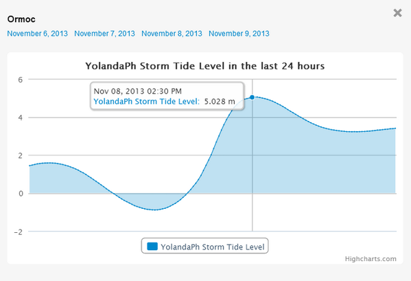
Haiyan is likely to push a devastating storm surge inland – at least 2 or 3 meters (around 10 feet) – just north of the center – along the eastern coast of southern Luzon and Samar islands.
Coastal and inland areas also face the likelihood of destructive winds, over 100 mph near the storm center.
“The worst of the storm will bypass the capital city of Manila, but damaging winds of 80 to 120 kph (50 to 75 mph) and rainfall of 100 to 200 mm (4 to 8 inches) are still expected,” notes AccuWeather.
The Wall Street Journal reports government agencies in the Philippines have been ordered to prepare emergency supplies and equipment ahead of the storm and will consider the need for evacuation procedures.
Haiyan is the 11th typhoon to form in the west Pacific in the last seven weeks, during what the UK Met Office calls an “exceptionally active period.”
It is the 5th super typhoon to form this year in the western Pacific.

2013 super typhoons (Brian McNoldy)
Wunderground meteorologist Jeff Masters notes Haiyan will be the fourth typhoon and fifth named storm to hit the Philippines in 2013.
“The Philippines lie in the most tropical cyclone-prone waters on Earth, and rarely escape a year without experiencing a devastating typhoon,” Masters writes.


Related: Extreme weather of 2013, in photos

No comments:
Post a Comment